Thursday, May 5, 2011

Chennai


Chennai (சென்னை)
Madras (மெட்ராஸ்)
—  Metropolitan city  —
Clock-wise from top: Chennai Central, Marina Beach,Kapaleeswarar Temple, Santhome Basilica, Bharatanatyam recital
Chennai (சென்னை)
Location of Chennai (சென்னை)
in Tamil Nadu and India
Chennai (Tamil: சென்னை[ˈtɕennəj]), formerly known as Madras (Tamil: மெட்ராஸ் or மதறாஸ்[mæˈdrəs]) or Madarasapatinam (மதராசப்பட்டினம்), is the capital city of the Indian state of Tamil Nadu, located on the Coromandel Coast of the Bay of Bengal. Chennai being the fourth most populous metropolitan areaand the fifth most populous city in India, it is also the world's 36th largest metropolitan area. Chennai had a population of 4.34 million in the 2001 census within the area administered by the Corporation of Chennai and an extended Metropolitan Population of 6.5 million. The urban agglomeration of metropolitan Chennai has an estimated population over 8.2 million people.
Chennai's economy has a broad industrial base in the automobile, computer, technology, hardware manufacturing, and healthcare industries. The city is India's second largest exporter of software, information technology (IT) and information-technology-enabled services (ITES). A major chunk of India's automobile manufacturing industry is based in and around the city. Chennai Zone contributes 39 per cent of the State's GDP. Chennai accounts for 60 per cent of the country's automotive exports, which leads it to be called as 'The Detroit of Asia'.
Chennai is an important centre for Carnatic music and hosts a large cultural event, the annual Madras Music Season, which includes performances by hundreds of artists. The city has a vibrant theatre scene and is an important centre for the Bharata Natyam, a classical dance form. The Tamil film industry, one of the largest film industries in India, also popularly known as Kollywood is based in the city; the soundtracks of the films dominate its music scene

Names


The name Chennai is a shortened form of Chennaipattinam, the name of the town that grew around Fort St. George, which was built by the English in 1640. There are two versions about the origin of the name Chennai: according to one version, Chennaipattinam was named after Damarla Chennappa Nayakudu, Nayaka of Kalahasthi and Vandavasi father of Damarla Venkatadri Nayakudu, from whom the English acquired the town in 1639. The first official use of the name Chennai is said to be in a sale deed, dated August 1639, to Francis Day of the English East India Company. According to the second account, Chennapattinam was named after the Chenna Kesava Perumal Temple; the word chenni in Tamil means face, and the temple was regarded as the face of the city.
The city's former name, Madras, is derived from Madraspattinam, a fishing village north of Fort St. George. There is some argument among researchers about the exact origin of the name Madraspattinam. It has been suggested that the Portuguese, who arrived in the area in the 16th century, may have named the village Madre de Deus. Another possibility is that the village's name came from the prominent Madeiros family (variously known as Madera or Madra in succeeding years) of Portuguese origin, which consecrated the Madre de Deus Church in the Santhome locality of Chennai in 1575. It is uncertain whether the name 'Madraspattinam' was in use before European influence.
Some time after the English gained possession of the area in the 17th century, the two towns, Madraspattinam and Chennapattinam, were merged, and the English referred to the united town as Madraspattinam. The state government officially changed the name to Chennai in 1996, at a time when many Indian cities were being renamed.

History


The region around Chennai has served as an important administrative, military, and economic centre since the 1st century. Stone age implements were found in a pit near Pallavaram in Chennai. According to the archeological survey of India, Pallavaram was a megalithic cultural establishment.
Fort St. George, ca. 1905
San Thome Cathedral Basilica, which was built in 16th century by Portuguese explorers
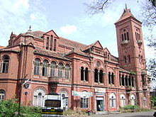
Victoria Public Hall, an example of a colonial building in Chennai
The area was ruled by various South Indian dynasties, notably the Pallava, the Chera Dynasty, the Chola, the Pandya, and Vijaynagar. The town of Mylapore, now part of Chennai, was once a major Pallavan port. The Portuguese arrived in 1522 and built a port called São Tomé after the Christian apostle, St Thomas, who is believed to have preached in the area between 52 and 70 AD. In 1612, the Dutch established themselves near Pulicat, just north of the city.
On 22 August 1639, Francis Day of the British East India Company bought a small strip of land on the Coromandel Coast. The region was ruled by Damarla Venkatadri Nayakudu,, the Nayaka of Vandavasi. He granted the British permission to build a factory and warehouse for their trading enterprises. A year later, the British built Fort St George, which became the nucleus of the growing colonial city. Fort St. George housed the Tamil Nadu Assembly until the new Secretariat building was opened in 2010. In 1746, Fort St. George and Madras were captured by the French under General La Bourdonnais, the Governor of Mauritius, who plundered the town and its outlying villages. The British regained control in 1749 through the Treaty of Aix-la-Chapelle and fortified the town's fortress wall to withstand further attacks from the French and another looming threat, Hyder Ali, the Sultan of Mysore. By the late 18th century, the British had conquered most of the region around Tamil Nadu and the northern modern-day states of Andhra Pradesh and Karnataka, establishing the Madras Presidency with Madras as the capital. Under British rule, the city grew into a major urban centre and naval base.
With the advent of railways in India in the late 19th century, the thriving urban centre was connected to other important cities such as Bombay and Calcutta, promoting increased communication and trade with the hinterland.
Madras was the only Indian city to be attacked by the Central Powers during World War I, when an oil depot was shelled by the German light cruiser SMS Emden on 22 September 1914, as it raided shipping lanes in the Indian Ocean, causing disruption to shipping.
After India gained its independence in 1947, the city became the capital of Madras State, renamed the state of Tamil Nadu in 1969. The violent agitations of 1965 against the imposition of Hindi as the national language, marked a major shift in the political dynamics of the city and the whole state.
On 26 December 2004, an Indian Ocean tsunami lashed the shores of Chennai, killing many and permanently altering the coastline.

Environment


Geography

Chennai is on the southeast coast of India in the northeast of Tamil Nadu on a flat coastal plain known as the Eastern Coastal Plains. Its average elevation is around 6.7 metres (22 ft), and its highest point is 60 m (200 ft). The Marina Beach runs for 12 km along the shoreline of the city. Two rivers meander through Chennai, theCooum River (or Koovam) through the centre and the Adyar River to the south. A third river, the Kortalaiyar, flows through the northern fringes of the city before draining into the sea at Ennore. Adyar and Cooum rivers are heavily polluted with effluents and waste from domestic and commercial sources. The state government periodically removes silt and pollution from the Adyar river, which is much less polluted than the Cooum. A protected estuary on the Adyar forms a natural habitat for several species of birds and animals. The Buckingham Canal, 4 km (2.5 mi) inland, runs parallel to the coast, linking the two rivers. The Otteri Nullah, an east-west stream, runs through north Chennai and meets the Buckingham Canal at Basin Bridge. Several lakes of varying size are located on the western fringes of the city. Red Hills, Sholavaram and Chembarambakkam Lake supply Chennai with potable water. Groundwater sources are becoming brackish.
Chennai is on a flat coastal plain, as shown on this Landsat 7 map.
Satellite image of Chennai by NASA Landsat
Chennai's soil is mostly clay, shale and sandstone. Sandy areas are found along the river banks and coasts, such as Thiruvanmiyur, Adyar, Kottivakkam, Santhome,George Town, Tondiarpet and the rest of coastal Chennai. Here rainwater runoff percolates quickly through the soil. Clay underlies most of the city including T. Nagar,West Mambalam, Anna Nagar, Villivakkam, Perambur and Virugambakkam. Areas of hard rock include Guindy, Perungudi, Velachery, Adambakkam and a part of Saidapet.[citation needed] Chennai is divided into four broad regions: North, Central, South and West. North Chennai is primarily an industrial area. Central Chennai is the commercial heart of the city and includes an important business district, Parry's Corner. South Chennai and West Chennai, previously mostly residential, are fast becoming commercial, home to a growing number of information technology firms, financial companies and call centres. The city is expanding quickly along the Old Mahabalipuram Road and the Grand Southern Trunk Road (GST Road) in the south and towards Ambattur, Koyambedu and Sriperumbdur in the west. Chennai is one of the few cities in the world that accommodates a national park, the Guindy National Park, within its limits.


Climate

Chennai has a tropical climate, specifically a tropical wet and dry climate. The city lies on the thermal equator[citation needed] and is also on the coast, which prevents extreme variation in seasonal temperature. The weather is hot and humid for most of the year. The hottest part of the year is late May to early June, known locally as Agni Nakshatram ("fire star") or as Kathiri Veyyil, with maximum temperatures around 38–42 °C (100–108 °F). The coolest part of the year is January, with minimum temperatures around 18–20 °C (64–68 °F). The lowest temperature recorded is 15.8 °C (60.4 °F) and highest 45 °C (113 °F) The average annual rainfall is about 140 cm (55 in). The city gets most of its seasonal rainfall from the north-east monsoon winds, from mid-October to mid-December. Cyclones in the Bay of Bengal sometimes hit the city. The highest annual rainfall recorded is 257 cm (101 in) in 2005. Prevailing winds in Chennai are usually southwesterly between April and October and northeasterly during the rest of the year.
[hide]Climate data for Chennai
MonthJanFebMarAprMayJunJulAugSepOctNovDecYear
Average high °C (°F)28.4
(83.1)
29.9
(85.8)
31.9
(89.4)
33.6
(92.5)
36.4
(97.5)
36.6
(97.9)
34.7
(94.5)
33.9
(93)
33.5
(92.3)
31.4
(88.5)
29.2
(84.6)
28.1
(82.6)
32.3
(90.1)
Average low °C (°F)20.6
(69.1)
21.2
(70.2)
23.1
(73.6)
25.9
(78.6)
27.6
(81.7)
27.2
(81)
25.9
(78.6)
25.3
(77.5)
25.3
(77.5)
24.3
(75.7)
22.8
(73)
21.6
(70.9)
24.2
(75.6)
Rainfall mm (inches)16.2
(0.638)
3.7
(0.146)
3.0
(0.118)
13.6
(0.535)
48.9
(1.925)
53.7
(2.114)
97.8
(3.85)
149.7
(5.894)
109.1
(4.295)
282.7
(11.13)
350.3
(13.791)
138.2
(5.441)
1,266.9
(49.878)
Avg. rainy days1.0.3.2.71.64.17.38.56.610.210.15.556.1
Sunshine hours269.7271.2294.5291.0279.0204.0186.0192.2198.0195.3183.0204.62,768.5
Source no. 1: WMO 
Source no. 2: HKO (sun only, 1971–1990) 


Water

Historically, Chennai has relied on annual monsoon rains to replenish water reservoirs, as no major rivers flow through the area. With a steadily increasing population, the city has faced water supply shortages, and its ground water levels have been depleted. An earlier Veeranam Lake project failed to solve the city's water problems, but the New Veeranam project, which became operational in September 2004, has greatly reduced dependency on distant sources. In recent years, heavy and consistent monsoon rains and rainwater harvesting (RWH) by Chennai Metrowater at its Anna Nagar Rain Centre have significantly reduced water shortages. Moreover, newer projects like the Telugu Ganga project that bring water from water-surplus rivers like the Krishna River in Andhra Pradesh have eased water shortages. The city has constructed a sea water desalination plant to further increase the water supply.